
Contents
Historical Background to the Inter- Linking of Rivers Project ( River Inter-Linking Project)
- In 1858, Sir Arthur Cotton proposed River Inter navigable canal links between major rivers to serve the East India Company and to deal with recurrent droughts in the south- eastern provinces.
- In 1972, India’s Irrigation & Power Minister Sh. K.L. Rao proposed an ambitious 2,640 Kn long canal that would transfer monsoon floodwaters from the Ganga to Cauvery in the South.
- In 1974, Dinshaw J. Dastur, advocated long distance irrigation through a network of ‘Garland Canals’ in the Himalayas and the Western Ghats.
- The Ministry of Water Resources formulated a National Perspective Plan (NPP) in 1980 envisaging inter basin transfer of water from surplus to deficit basins.
- In 1982, the National Water Development Agency (NWDA) was formed to carry out water balance and feasibility studies of the linking programme of 30 rivers.
- Under the Vajpayee government, it was planned to connect 14 Himalayan and 16 Peninsular rivers by constructing 30 canals and 3,000 reservoirs to irrigate 87 million hectares of land, and produce 34 GW of electricity.
- The Supreme Court in 2002 formed a task force, which set up an action plan for all detailed project reports (DPRs) of river inter-linking projects to be completed by 2006.
- In 2012, the Supreme Court gave its nod for the river inter-linking project. It asked the government to ensure that the project is implemented expeditiously.
- The project received a renewed momentum after the Modi government came to power. It envisages linking the rivers to enable inter-basin transfer of water from surplus to deficit basins, so that the variations in availability of water in different regions are narrowed and the scarce resource is utilized optimally.
Project ( River Inter )
- The idea is to cut canals between two rivers and let water flow from one to the other.
- A dam will be built at the ‘from’ end to raise the level and then gravity will take over.
- Thus, a system of canals and dams will create water grids in the northern and the southern parts of India.
Favor ( River Inter )
- Climate change will continue River Inter to affect weather conditions and create water shortages and excesses. The recent drought in Latur district of Maharashtra is one such example. The solution lies in expediting the river linking project which aims to transfer water from surplus basins to those having deficiency of water. This could be achieved by building a network of dams and canals across the country.
- The programme has a potential of irrigating more than two lakh hectares of land. This will check migration of farmers to greener pastures.
- It will boost per capita water availability for millions of water starved Indians.
- It will ultimately remove the swings between floods and droughts when about a third of the area is drought-prone and another eighth is flood-prone.
- India needs to add hydro power. At the Paris Conference on climate, the Indian government has committed that by 2030, non-fossil fuel based power will form 40 percent of the total capacity.
- Water transfer projects have been done for centuries which is evident from the 5,000 Km of canals that India has. For example, the Indira Gandhi canal, which transports water from the Beas and the Satluj, to the deserts of Rajasthan. This has turned Rajasthan into a water surplus state.
- The new Right to Fair Compensation and transparency in Land Acquisition, Rehabilitation and Resettlement act, 2013, provides security to the displaced. Each project will have an Administrator of Rehabilitation to oversee the process of Resettlement and Rehabilitation. Rs. 66 lakhs a family will be spent on compensation, creation of alternative sites and training.
- The project also offers enormous scope for employment.
Against ( River Inter)
- It could displace millions of people due to the submergence of 27.66 lakh hectares of land.
- The overall land area going under includes 104,000 hectares currently under natural forest cover, including reserves and sanctuaries.
- It will cost around Rs. 11 lakh crore to the exchequer and 15,000 Km of new canals will have to be added. The cost includes land acquisition, compensation and construction.
- It will affect the natural ecology of the rivers.
- The Ganga basin’s topography is flat, this means that constructing dams will not substantially add to river flows.
- The dams could threaten the forests of the Himalayas.
- It will impact the functioning of the monsoon system. Inflows from rivers help maintain high sea-surface temperatures in the Bay of Bengal, critical for creating low pressure areas and intensification of the monsoon. Reducing the flow of river waters into the sea could bear serious long term consequences for climate and rainfall in the sub-continent.
- Curbing demand by efficient utilization of existing water resources should be prioritized before making huge investments in the project.
- The judicious use of canal water, growing crops appropriate for a region, encouraging drip irrigation and reviving traditional systems such as tanks can also be considered instead of investing in large dam constructions.
- The project has been majorly proposed to benefit the construction lobby.
- Issues such as protection of flora and fauna and the dumping of the silt dredged out of dams have been often raised.
- The project entails environmental tinkering on an epic scale which includes destruction of natural rivers, aquatic and terrestrial biodiversity, salinity ingress and a significant increase in methane emissions from storage reservoirs.
Challenges
- There is opposition from water endowed states. None of the water-rich states are willing to accept that they have surplus water to share. Getting state governments on board is a big issue.
- A study conducted by IIT Bombay and IIT Madras has found a decrease in the monsoon rainfall over major water surplus river basins, and no increase in rainfall over major water deficit river basins. This change in rainfall pattern over major river basins in India raises concerns regarding the suitability and viability of the project. Hence water demand in a surplus basin first needs to be assessed and then met under decreasing water availability scenarios before transferring water to deficit basins.
- Resettlement and Rehabilitation – the project is likely to displace at least 6 lakh people. Earlier records, for example, the Tehri dam project exposed affected people to many unforeseen difficulties. Even if the affected people were resettled, their rehabilitation was not complete.
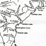
Since late last year, the scheme has been implemented by the Central Government in several segments such as the Godavari-Krishna interlink in Andhra Pradesh, and the Ken-Betwa interlink in Madhya Pradesh.
Godavari-Krishna Link
- The Godavari-Krishna river inter-linking project has been completed to divert 80 TMC of water from Godavari to Krishna.
- This linkage has been made possible by the Pattiseema Lift Irrigation Scheme on Godavari river.
- It is the first river inter-linking project in the country.
Also Read:-India-Indonesia Relations