Our Country India : Class 6-Chapter 7 Geography
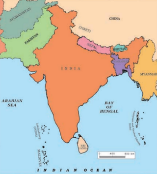
- India is a peninsula, which is a piece of land that is surrounded by water on three sides. It has:
- Himalayas in the North.
- The Arabian Sea in the West.
- The Bay of Bengal in the East.
- The Indian Ocean in the South.
- India has an area of about 3.28 million sq. Km.
- The North-South extent of India is 3,200 Km and the East-West extent is 2,900 Km.
- The country has 29 states and 7 union territories.
- Rajasthan is the largest state and Goa the smallest in terms of area.
Locational Setting
- India is located in the Northern hemisphere.
- The Tropic of Cancer (23º30’N) passes almost halfway through the country.
- From south to north, the mainland of India extends between 8º4’N and 37º6’N latitudes.
- From west to east, India extends between 68º7’E and 97º25’E longitudes.
- Due to a great longitudinal extent of about 29º, there could be a wide difference in local time between places located at two extreme points of India.
- It is known that the local time changes by four minutes for every one degree of longitude. As such, the difference between these two points would be of about two hours. So, the sun rises two hours earlier in Arunachal Pradesh than in Gujarat.
- The local time of longitude 82º30’E has been taken as the Indian Standard Time. This meridian or longitude is also termed as the Standard Meridian of India.
- Large countries like USA, Canada and Russia,which stretch extensively from east to west do not have a single Standard Time like India.
India’s Neighbours
- There are seven countries that share land boundaries with India.These are Afghanistan, Bangladesh, Bhutan, China, Myanmar, Nepal and Pakistan.
- Afghanistan, Nepal and Bhutan do not have access to any ocean or sea.
- Sri Lanka and Maldives are India’s island neighbours in the south.
- Sri Lanka is separated from India by the Palk Strait.
Physical Divisions
- In the north are the lofty snow-capped Himalayas. They are divided into three main parallel ranges.
a. The northernmost is the Great Himalaya or Himadri. It consists of some of the world’s highest peaks.
b. Middle Himalaya or Himachal lies to the south of Himadri. It has many popular hill stations.
c. The Shiwalik is the southernmost range.
2. The Northern Indian Plains lie to the south of the Himalayas and are generally level and flat.
- These are formed by the alluvial deposits laid down by the rivers- the Indus, the Ganga, the Brahmaputra and their tributaries.
- Alluvial deposits are very fine soils, brought by rivers and deposited in the river basins.
- A tributary is a river or a stream which contributes its water to a main river from either side.
- The river plains provide fertile land for cultivation which is the reason for high concentration of population in these plains.

3. In the western part of India lies the Great Indian Desert.
- It is a dry, hot and sandy stretch of land and has very little vegetation.
4. To the south of northern plains lies the Peninsular plateau.
- It is triangular in shape and the relief (the differences in elevation and slope between the higher and lower parts of the land surface of a given area) is highly uneven.
- This is a region with numerous hill ranges and valleys.
- Aravalli hills, one of the oldest ranges in the world, border it on the north-west side.
- The Vindhyas and the Satpuras are the important ranges. The rivers Narmada and Tapi flow through these ranges and are west-flowing rivers that drain into the Arabian Sea.
- The Western Ghats or Sahyadris (they are almost continuous) border the plateau in the west and the Eastern Ghats (broken and uneven) provide the eastern boundary.
- The plateau is rich in minerals like coal and iron-ore.
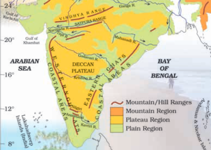
5. To the west of the Western Ghats and the East of the Eastern Ghats lie the Coastal plains.
- The western coastal plains are very narrow.
- The eastern coastal plains are much broader.
- There are a number of east flowing rivers like Mahanadi, Godavari, Krishna and Kaveri that drain into the Bay of Bengal.
- The Sunderban delta is formed where the Ganga and the Brahmaputra flow into the Bay of Bengal. It is the world’s largest delta. A delta is triangular in shape and is an area of land formed at the mouth of the river (where rivers enter the sea, that point is called the mouth of the river).
6. Two groups of islands also form part of India.
- Lakshadweep Islands are located in the Arabian Sea.
- These are coral islands located off the coast of Kerala.
- Corals are skeletons of tiny marine animals called Polyps. When the living polyps die, their skeletons are left. Other polyps grow on top of the hard skeleton which grows higher and higher, thus forming the coral island.
- The Andaman & the Nicobar Islands lie to the south-east of the Indian mainland in the Bay of Bengal.